
“A Total Surprise” – Geologists Uncover New Origin Story for Deadly Seattle Fault
The Seattle fault zone, a network of shallow faults threatening the Puget Sound region, has a new origin story based on a study published in Tectonics that suggests its formation around 55 million years ago due to tectonic deformation. This study, revealing ancient volcanic island interactions with the North American plate, aims to enhance hazard modeling for the densely populated area.
Magnetic evidence indicates that the dangerous Seattle fault zone may have originated from the continent’s edge splitting in half over 50 million years ago, offering a potential new explanation for the fault’s formation.
The Seattle fault zone consists of a series of shallow faults cutting across the Puget Sound lowlands, posing a risk of destructive earthquakes to the over four million inhabitants of the area. A recent study offers a fresh perspective on the fault system’s initial formation, aiming to enhance the prediction and understanding of potential hazards for this heavily populated area. The study was published in Tectonics, AGU’s journal for research exploring the evolution, structure, and change of Earth’s crust and upper mantle.
The Seattle fault is active today because of forces exerted on the region from ongoing tectonic deformation both to the west and south, but that was not always the case. Washington in the Eocene looked different from today, with a coastline well east of where Seattle sits today and a chain of volcanic islands dotting the horizon offshore.
The study suggests that around 55 million years ago, that island chain was pulled toward the continent. As it ran into the North American plate, part of it went up and over the crust while the rest was sucked under it. Between these two parts, the crust would have been under great strain and torn. That ancient tear zone set the geologic stage for the modern Seattle fault, the study authors posit.
“It was a total surprise,” said Megan Anderson, a geophysicist with the Washington Geological Survey and lead author of the study. “It wasn’t something we were going for originally, but our results predict a major ancient fault where the Seattle fault is today.”
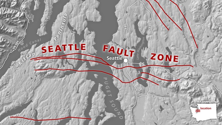
The modern Seattle fault zone cuts directly through the densely populated Puget lowlands, including Seattle and its metro area. Fifty million years ago, the continent tore in two here, setting the geologic stage for the modern faults, according to a new Tectonics study. Credit: Washington Geological Survey.
A massive mystery
The Pacific Northwest lies just inland from the Cascadia subduction zone, where dense oceanic crust gets pulled under the continent. In 1700, a roughly 1000-kilometer (620-mile) rupture of the subduction zone created a massive quake between magnitude 8.7 and 9.2; smaller quakes shook the region throughout the 1900s and, most recently, during the 2001 Nisqually earthquake. The Seattle fault ruptured notably in 923-924 AD, based on local Indigenous oral traditions and geologic evidence along the Puget Sound shoreline.
Despite the region’s seismic activity, scientists didn’t begin to study the Seattle fault zone in earnest until the 1990s.
“There’s a lot more uncertainty about the Seattle fault than, for example, the San Andreas fault,” Anderson said. “The Seattle fault could generate something like a magnitude 7.2 earthquake, and we want to be prepared for it. There’s still a lot to learn so that engineering geologists can do better simulations for earthquakes and understand the potential risks to our communities.”
Previous work to determine the geometry of the Seattle fault at depth relied primarily on seismic data, which are sound waves traveling through and being reflected by underground layers of rock. The data revealed faults and geologic structures that seismologists and geologists interpreted differently. They knew the region hosted a major fault zone, but scientists had proposed different ways parts of the fault are connected, how deep it extends, and how steeply it cuts through the bedrock.
Anderson and her co-authors set out to test the existing hypotheses of the fault zone’s geometry by mapping kilometers-deep bedrock across western Washington and building a more complete picture of the region’s geologic structure. Gravity and magnetic fields vary across Earth’s surface based on rocks’ density and composition, so Anderson compiled those data for western Washington and paired them with seismic data. The researchers also collected rock samples from geologic formations that correspond to different parts of the ancient fault and mountain system.
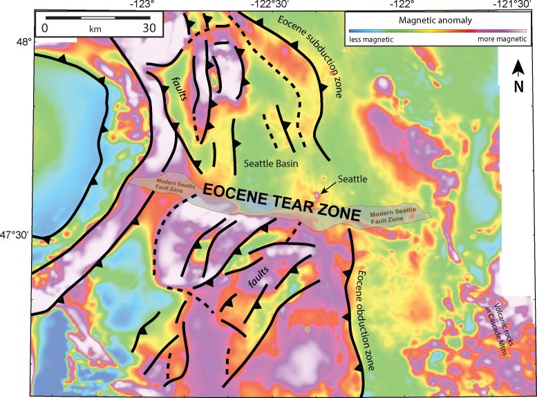
Aerially collected magnetic data (background colors) of western Washington reveal that faults (black lines) on either side of the modern Seattle fault are oriented in different directions, suggesting a significant disconnect between the north and south. A massive tear between subducting and obducting (sinking and accumulating) material could have formed from the strain, authors of a new Tectonics study posit. Credit: modified from Anderson et al./Tectonics
The researchers used computer models to see which, if any, of the hypotheses matched up with the gravity, magnetic, and seismic data. The gravity data did not show a complex pattern, but the magnetic data revealed a key secret seismic data missed: deep in the crust, the bedrock consistently alternates between being more and less magnetic, suggesting slanted layers of changing rock type. And in map view, features on either side of the Seattle fault zone angle away from each other; north of the Seattle fault zone, structures are angled north-northwest, while in the south, they’re oriented north-northeast.
Those wonky orientations gave Anderson pause; they hinted at an ancient mountain range, but to check that, Anderson needed to match up the map-view data with deeper rocks. To connect the map view with known, deeper bedrock geology, Anderson modeled a vertical profile of rocks underground and found some of those structures dip at different orientations underground, too.
“These are all very different orientations,” Anderson said. “It’s very hard to do that unless there’s a place where the structures get disconnected from each other and then restart.”
Anderson had stumbled upon a new possible explanation for the Seattle fault zone’s early history and why it’s reactivated today.
A tear in the crustal continuum
The data suggested that about 55 million years ago, as the subduction zone pulled in a string of oceanic islands, the northern half of the island chain was subducted, but the southern half was added to the top of the crust, or obducted. Over a couple million years, as the islands were obducted, they crumpled into a fold-and-thrust mountain belt with topography similar to the Blue Ridge Mountains of Appalachia today.
The zone where the islands switched from being subducted to being accreted would have been under incredible strain and been ripped apart.
“It would have been this slow, ongoing tear, almost like the crust unzipping itself,” Anderson said. “As this progressed, the tear fault got longer and longer.”
And that “torn” region overlaps perfectly with the modern Seattle fault zone.
The intense tearing would have stopped after the islands were crunched into the continent, but the damage was done. The zone of intense tearing created fragmented, weakened crust, setting the geologic stage for the modern Seattle fault zone.
Beyond offering a possible explanation for why the fault zone exists, the study’s results about the geometry of Washington’s more ancient faults and geologic structures provide valuable details about the bedrock under and within the Seattle basin. This basin is filled with kilometers of looser sedimentary rock which make seismic ground shaking stronger, and the new data can help scientists make more accurate models of future ground shaking in the area.
Anderson is excited to use her findings to study western Washington’s active faults next.
“This buried tectonic story was so much fun to discover, and now it will provide a great basis for getting back to answering our original questions about active fault geometry for the Seattle fault and other faults in western Washington,” Anderson said.
Reference: “Deep Structure of Siletzia in the Puget Lowland: Imaging an Obducted Plateau and Accretionary Thrust Belt With Potential Fields” by M. L. Anderson, R. J. Blakely, R. E. Wells and J. D. Dragovich, 06 February 2024, Tectonics.
DOI: 10.1029/2022TC007720
The Seattle fault zone, a network of shallow faults threatening the Puget Sound region, has a new origin story based on a study published in Tectonics that suggests its formation around 55 million years ago due to tectonic deformation. This study, revealing ancient volcanic island interactions with the North American plate, aims to enhance hazard modeling for the densely populated area.
Magnetic evidence indicates that the dangerous Seattle fault zone may have originated from the continent’s edge splitting in half over 50 million years ago, offering a potential new explanation for the fault’s formation.
The Seattle fault zone consists of a series of shallow faults cutting across the Puget Sound lowlands, posing a risk of destructive earthquakes to the over four million inhabitants of the area. A recent study offers a fresh perspective on the fault system’s initial formation, aiming to enhance the prediction and understanding of potential hazards for this heavily populated area. The study was published in Tectonics, AGU’s journal for research exploring the evolution, structure, and change of Earth’s crust and upper mantle.
The Seattle fault is active today because of forces exerted on the region from ongoing tectonic deformation both to the west and south, but that was not always the case. Washington in the Eocene looked different from today, with a coastline well east of where Seattle sits today and a chain of volcanic islands dotting the horizon offshore.
The study suggests that around 55 million years ago, that island chain was pulled toward the continent. As it ran into the North American plate, part of it went up and over the crust while the rest was sucked under it. Between these two parts, the crust would have been under great strain and torn. That ancient tear zone set the geologic stage for the modern Seattle fault, the study authors posit.
“It was a total surprise,” said Megan Anderson, a geophysicist with the Washington Geological Survey and lead author of the study. “It wasn’t something we were going for originally, but our results predict a major ancient fault where the Seattle fault is today.”
The modern Seattle fault zone cuts directly through the densely populated Puget lowlands, including Seattle and its metro area. Fifty million years ago, the continent tore in two here, setting the geologic stage for the modern faults, according to a new Tectonics study. Credit: Washington Geological Survey.
A massive mystery
The Pacific Northwest lies just inland from the Cascadia subduction zone, where dense oceanic crust gets pulled under the continent. In 1700, a roughly 1000-kilometer (620-mile) rupture of the subduction zone created a massive quake between magnitude 8.7 and 9.2; smaller quakes shook the region throughout the 1900s and, most recently, during the 2001 Nisqually earthquake. The Seattle fault ruptured notably in 923-924 AD, based on local Indigenous oral traditions and geologic evidence along the Puget Sound shoreline.
Despite the region’s seismic activity, scientists didn’t begin to study the Seattle fault zone in earnest until the 1990s.
“There’s a lot more uncertainty about the Seattle fault than, for example, the San Andreas fault,” Anderson said. “The Seattle fault could generate something like a magnitude 7.2 earthquake, and we want to be prepared for it. There’s still a lot to learn so that engineering geologists can do better simulations for earthquakes and understand the potential risks to our communities.”
Previous work to determine the geometry of the Seattle fault at depth relied primarily on seismic data, which are sound waves traveling through and being reflected by underground layers of rock. The data revealed faults and geologic structures that seismologists and geologists interpreted differently. They knew the region hosted a major fault zone, but scientists had proposed different ways parts of the fault are connected, how deep it extends, and how steeply it cuts through the bedrock.
Anderson and her co-authors set out to test the existing hypotheses of the fault zone’s geometry by mapping kilometers-deep bedrock across western Washington and building a more complete picture of the region’s geologic structure. Gravity and magnetic fields vary across Earth’s surface based on rocks’ density and composition, so Anderson compiled those data for western Washington and paired them with seismic data. The researchers also collected rock samples from geologic formations that correspond to different parts of the ancient fault and mountain system.
Aerially collected magnetic data (background colors) of western Washington reveal that faults (black lines) on either side of the modern Seattle fault are oriented in different directions, suggesting a significant disconnect between the north and south. A massive tear between subducting and obducting (sinking and accumulating) material could have formed from the strain, authors of a new Tectonics study posit. Credit: modified from Anderson et al./Tectonics
The researchers used computer models to see which, if any, of the hypotheses matched up with the gravity, magnetic, and seismic data. The gravity data did not show a complex pattern, but the magnetic data revealed a key secret seismic data missed: deep in the crust, the bedrock consistently alternates between being more and less magnetic, suggesting slanted layers of changing rock type. And in map view, features on either side of the Seattle fault zone angle away from each other; north of the Seattle fault zone, structures are angled north-northwest, while in the south, they’re oriented north-northeast.
Those wonky orientations gave Anderson pause; they hinted at an ancient mountain range, but to check that, Anderson needed to match up the map-view data with deeper rocks. To connect the map view with known, deeper bedrock geology, Anderson modeled a vertical profile of rocks underground and found some of those structures dip at different orientations underground, too.
“These are all very different orientations,” Anderson said. “It’s very hard to do that unless there’s a place where the structures get disconnected from each other and then restart.”
Anderson had stumbled upon a new possible explanation for the Seattle fault zone’s early history and why it’s reactivated today.
A tear in the crustal continuum
The data suggested that about 55 million years ago, as the subduction zone pulled in a string of oceanic islands, the northern half of the island chain was subducted, but the southern half was added to the top of the crust, or obducted. Over a couple million years, as the islands were obducted, they crumpled into a fold-and-thrust mountain belt with topography similar to the Blue Ridge Mountains of Appalachia today.
The zone where the islands switched from being subducted to being accreted would have been under incredible strain and been ripped apart.
“It would have been this slow, ongoing tear, almost like the crust unzipping itself,” Anderson said. “As this progressed, the tear fault got longer and longer.”
And that “torn” region overlaps perfectly with the modern Seattle fault zone.
The intense tearing would have stopped after the islands were crunched into the continent, but the damage was done. The zone of intense tearing created fragmented, weakened crust, setting the geologic stage for the modern Seattle fault zone.
Beyond offering a possible explanation for why the fault zone exists, the study’s results about the geometry of Washington’s more ancient faults and geologic structures provide valuable details about the bedrock under and within the Seattle basin. This basin is filled with kilometers of looser sedimentary rock which make seismic ground shaking stronger, and the new data can help scientists make more accurate models of future ground shaking in the area.
Anderson is excited to use her findings to study western Washington’s active faults next.
“This buried tectonic story was so much fun to discover, and now it will provide a great basis for getting back to answering our original questions about active fault geometry for the Seattle fault and other faults in western Washington,” Anderson said.
Reference: “Deep Structure of Siletzia in the Puget Lowland: Imaging an Obducted Plateau and Accretionary Thrust Belt With Potential Fields” by M. L. Anderson, R. J. Blakely, R. E. Wells and J. D. Dragovich, 06 February 2024, Tectonics.
DOI: 10.1029/2022TC007720
Denial of responsibility! Techno Blender is an automatic aggregator of the all world’s media. In each content, the hyperlink to the primary source is specified. All trademarks belong to their rightful owners, all materials to their authors. If you are the owner of the content and do not want us to publish your materials, please contact us by email – [email protected]. The content will be deleted within 24 hours.