
Death Valley’s Persistent Lake Explored
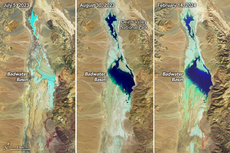
Satellite images of Death Valley’s Badwater Basin captured on July 5, 2023; August 30, 2023; and February 14, 2024.
Refreshed by precipitation from an atmospheric river, a temporary lake in Death Valley is extending its stay.
An ephemeral lake in Death Valley’s Badwater Basin is showing its staying power. After forming in August 2023 in the aftermath of Hurricane Hilary, the lake gradually shrank but persisted throughout the fall and winter. A potent atmospheric river filled it back up in February 2024.
This series of images compares the desert basin before flooding (left) with its more-waterlogged state following each major storm. In both August 2023 (middle) and February 2024 (right), a shallow lake several kilometers across fills in the low-lying salt flat. The images were acquired by the OLI (Operational Land Imager) sensor on Landsat 8 (left and right) and the OLI-2 on Landsat 9 (middle). They are false-color, shown with the OLI and OLI-2 band combination of 6-5-3, which emphasizes the presence of water in shades of blue.
Unprecedented Rainfall in Death Valley
The driest place in North America, Death Valley typically receives about 2 inches (51 millimeters) of rain per year. However, in the past six months alone, more than double that—4.9 inches (125 millimeters)—fell at the national park’s official weather gauge at Furnace Creek. Two events were responsible for most of that precipitation. The remnants of Hurricane Hilary delivered 2.2 inches on August 20, 2023, and an atmospheric river brought another 1.5 inches from February 4–7, 2024, according to park officials.
Following the August deluge, “most of us thought the lake would be gone by October,” said Death Valley National Park ranger Abby Wines in a news release. “We were shocked to see it still here after almost six months.” That was before the rains returned in February.
After the early February atmospheric river moved through, observers on the ground saw the lake continue to expand as water drained into the area. On February 11, park ranger Matthew Lamar noted: “The Amargosa River [which feeds the basin from the south] is really flowing, and we’ve noticed the water level continue to rise over the last couple of days as waters make their way to the basin.”
Reflections and Future Uncertainty
Badwater Basin is endorheic, meaning that water flows into but not out of it. Typically, evaporation far outpaces inputs, rendering the lake ephemeral. But in the past six months, the influxes have changed the equation.
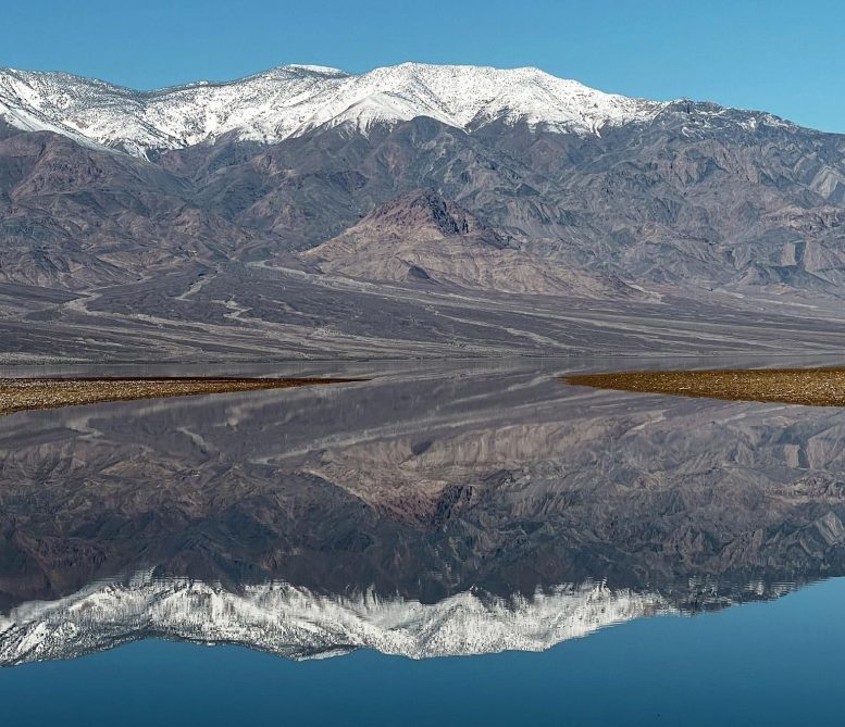
Badwater Basin on February 12, 2024.
Based on satellite imagery, the lake appears to have grown to a similar size in February 2024 as it did in August 2023, thereby extending its months-long tenure. This comes as welcome news to visitors, who have enjoyed witnessing stunning reflections of the surrounding peaks in its calm waters.
As of February 14, the lake is 1 foot deep in places, according to park officials, and it is uncertain how long it will last. Past appearances of the lake are rare and offer little insight into the current situation; when a lake formed in 2005, for example, it reportedly lasted about one week. It is also too early to know how the precipitation will affect the wildflower season, which runs from late-February to mid-April, they said.
NASA Earth Observatory images by Wanmei Liang, using Landsat data from the U.S. Geological Survey. Photo by K. Skilling/National Park Service.
Satellite images of Death Valley’s Badwater Basin captured on July 5, 2023; August 30, 2023; and February 14, 2024.
Refreshed by precipitation from an atmospheric river, a temporary lake in Death Valley is extending its stay.
An ephemeral lake in Death Valley’s Badwater Basin is showing its staying power. After forming in August 2023 in the aftermath of Hurricane Hilary, the lake gradually shrank but persisted throughout the fall and winter. A potent atmospheric river filled it back up in February 2024.
This series of images compares the desert basin before flooding (left) with its more-waterlogged state following each major storm. In both August 2023 (middle) and February 2024 (right), a shallow lake several kilometers across fills in the low-lying salt flat. The images were acquired by the OLI (Operational Land Imager) sensor on Landsat 8 (left and right) and the OLI-2 on Landsat 9 (middle). They are false-color, shown with the OLI and OLI-2 band combination of 6-5-3, which emphasizes the presence of water in shades of blue.
Unprecedented Rainfall in Death Valley
The driest place in North America, Death Valley typically receives about 2 inches (51 millimeters) of rain per year. However, in the past six months alone, more than double that—4.9 inches (125 millimeters)—fell at the national park’s official weather gauge at Furnace Creek. Two events were responsible for most of that precipitation. The remnants of Hurricane Hilary delivered 2.2 inches on August 20, 2023, and an atmospheric river brought another 1.5 inches from February 4–7, 2024, according to park officials.
Following the August deluge, “most of us thought the lake would be gone by October,” said Death Valley National Park ranger Abby Wines in a news release. “We were shocked to see it still here after almost six months.” That was before the rains returned in February.
After the early February atmospheric river moved through, observers on the ground saw the lake continue to expand as water drained into the area. On February 11, park ranger Matthew Lamar noted: “The Amargosa River [which feeds the basin from the south] is really flowing, and we’ve noticed the water level continue to rise over the last couple of days as waters make their way to the basin.”
Reflections and Future Uncertainty
Badwater Basin is endorheic, meaning that water flows into but not out of it. Typically, evaporation far outpaces inputs, rendering the lake ephemeral. But in the past six months, the influxes have changed the equation.
Badwater Basin on February 12, 2024.
Based on satellite imagery, the lake appears to have grown to a similar size in February 2024 as it did in August 2023, thereby extending its months-long tenure. This comes as welcome news to visitors, who have enjoyed witnessing stunning reflections of the surrounding peaks in its calm waters.
As of February 14, the lake is 1 foot deep in places, according to park officials, and it is uncertain how long it will last. Past appearances of the lake are rare and offer little insight into the current situation; when a lake formed in 2005, for example, it reportedly lasted about one week. It is also too early to know how the precipitation will affect the wildflower season, which runs from late-February to mid-April, they said.
NASA Earth Observatory images by Wanmei Liang, using Landsat data from the U.S. Geological Survey. Photo by K. Skilling/National Park Service.
Denial of responsibility! Techno Blender is an automatic aggregator of the all world’s media. In each content, the hyperlink to the primary source is specified. All trademarks belong to their rightful owners, all materials to their authors. If you are the owner of the content and do not want us to publish your materials, please contact us by email – [email protected]. The content will be deleted within 24 hours.