
MapMyIndia launches indigenously developed street view called Mappls RealView
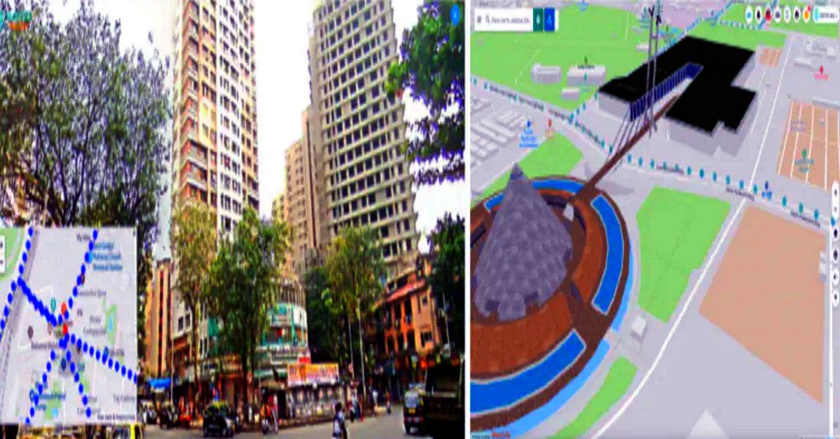
Move over Google Maps’ StreetView, India’s very own Mappls is here. MapMyIndia – an Indian company that develops navigation software and hardware has come up with a brand new street view service called the Mappls RealView. Apart from showing a 360 degree panoramic street view of major Indian cities, Mappls also offers 3D maps on the Metaverse.
Through Mappls RealView, users can check out 360 degree views from Greater Mumbai, Bengaluru, Delhi NCR, Goa, Pune, Hyderabad, Chennai, Jaipur,
Ahmedabad, Gandhinagar, Chandigarh, Jodhpur, Patna, Nashik, Aurangabad, Ajmer and hundreds more towns and tens of thousands of kilometres of highways connecting these cities and towns.
Also read: 10 DC Design cars & how they look in the REAL world: Maruti Swift to Mahindra XUV500
This is not all. Users can get interactive, 360 degree panoramic views of tourist landmarks, beaches, residential colonies and apartment societies, office towers and the roads connecting these places. This service is available on multiple platforms. Desktop users may log in to www.mappls.com while mobile users can download the Mappls app on Android and iOS devices. As of now, this service is offered at no cost.
Rohan Verma, CEO & Executive Director, MapmyIndia, had this to say about the Mappls RealView service,
With Mappls RealView on https://www.mappls.com and Mappls App, users can virtually explore India like never before and see and interact with full 360-degree panoramas of streets and roads looking out into various tourist, residential and commercial areas of cities and travel destinations as well as highways. Users can also experience immersive 3D maps for pan India and detailed interactive 3D models of iconic tourist, commercial and residential landmarks across India. This, combined with Mappls’ detailed house-address level 2D maps from MapmyIndia and ISRO’s rich catalogue of satellite imagery and Earth observation data which MapmyIndia has integrated, gives a full & immersive Real World Metaverse experience to users, all indigenously built in India by India’s leading advanced digital maps and deep-tech company MapmyIndia. We are excited to give to users in India, a fully indigenous alternative to foreign map apps, that is more advanced in its capabilities and is more valuable for users, while also being fully Indian. We hope users in India will try out Mappls and give us feedback so we can keep improving. This is the right way to achieve the clarion call for Aatmanirbhar Bharat given by our Honourable Prime Minister, Shri Narendra Modi ji”
Also read: Upcoming 2022 Maruti Suzuki Vitara Brezza rendered
Denial of responsibility! Techno Blender is an automatic aggregator of the all world’s media. In each content, the hyperlink to the primary source is specified. All trademarks belong to their rightful owners, all materials to their authors. If you are the owner of the content and do not want us to publish your materials, please contact us by email – [email protected]. The content will be deleted within 24 hours.