
Saildrone completes epic mapping mission around Aleutian Islands
In July last year, Saildrone launched one its sensor-packed unmanned aquatic drones on a voyage of discovery in the North Pacific, tasked with filling in ocean mapping blanks around Alaska’s Aleutian Islands as well as off the coast of California.
Despite being one of the world’s largest Exclusive Economic Zones (EEZ), the waters around the United States are reported to be mostly “unmapped, unobserved and unexplored.” Seafloor mapping by crewed research ships can prove challenging, expensive and time consuming, and that’s where Saildrone’s vessels can help.
Though Saildrone’s Explorer has grabbed much of the attention since we were first introduced to the 7-m-long (23-ft) unmanned surface vehicle in 2018 – chasing hurricanes in the Atlantic and recording footage from inside Hurricane Sam – the Alaska mission was undertaken by the company’s much larger Surveyor model.
The Surveyor SD 1200 set off from Saildrone’s headquarters in Alameda, California, in July 2022 to embark on a months-long ocean mapping and environmental data survey of one of the most remote and understudied regions in the US EEZ.
Saildrone
The uncrewed vessel is 20 m long (65 ft) and sports a 44-ft-high (13-m) wing to catch the wind and push it forward at an average of five knots (5.7 mph/9.3 km/h), though there is an auxiliary 78-hp diesel system onboard, and the vehicle can sprint to 10 knots when needed. The body of the vehicle also hosts photovoltaic panels to power electronics and its instrument suite designed to gather acoustic, oceanographic and meteorological data.
An Environmental Sample Processor from the Monterey Bay Aquarium Research Institute went along for the trip too – a “lab in a can” for gathering data on marine diversity and ocean health using “genetic ‘fingerprints’ left behind by marine life.”
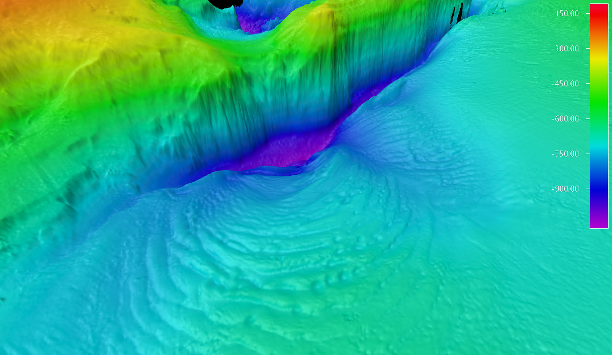
By October, the SD 1200 had brushed off 35-knot winds and survived swells of more than 5 meters (16 ft) to map 16.524 sq km (4,739 sq nm) of previously uncharted seafloor around the Aleutian Islands over a 52-day stint. But the Surveyor still had work to do, and subsequently set off to map an area off the coast of California – successfully recording data over an area of 29,720 sq km (8.665 sq nm) and even discovering a previously unknown 1,000-m-high (3,200-ft) seamount along the way.
Saildrone
“Surveyor brings a new and exciting capability for ocean exploration and mapping,” said VP of Ocean Mapping at Saildrone, Brian Connon. “Mapping in the Aleutians is not trivial, and the conditions there can be austere any time of year. The Surveyor weathered the storms, collected high-resolution bathymetry, and put no humans at risk. This mission proves that long-endurance USVs provide a viable option to achieve the goals of the National Ocean Mapping, Exploration, and Characterization Strategy. This is the future of ocean mapping.”
The multi-partner project was primarily funded by the National Oceanic and Atmospheric Administration (NOAA) and the Bureau of Ocean Energy Management, with at-sea operations managed by NOAA’s Ocean Exploration staff and the University of New Hampshire’s Center for Coastal and Ocean Mapping.
Once the data gathered from the Aleutian Islands mission has been processed, it will be made publicly available via NOAA’s National Centers for Environmental Information portal, while also being used to optimize dive targets for future crewed missions to the area by NOAA’s Okeanos Explorer.
Source: Saildrone
In July last year, Saildrone launched one its sensor-packed unmanned aquatic drones on a voyage of discovery in the North Pacific, tasked with filling in ocean mapping blanks around Alaska’s Aleutian Islands as well as off the coast of California.
Despite being one of the world’s largest Exclusive Economic Zones (EEZ), the waters around the United States are reported to be mostly “unmapped, unobserved and unexplored.” Seafloor mapping by crewed research ships can prove challenging, expensive and time consuming, and that’s where Saildrone’s vessels can help.
Though Saildrone’s Explorer has grabbed much of the attention since we were first introduced to the 7-m-long (23-ft) unmanned surface vehicle in 2018 – chasing hurricanes in the Atlantic and recording footage from inside Hurricane Sam – the Alaska mission was undertaken by the company’s much larger Surveyor model.
The Surveyor SD 1200 set off from Saildrone’s headquarters in Alameda, California, in July 2022 to embark on a months-long ocean mapping and environmental data survey of one of the most remote and understudied regions in the US EEZ.

Saildrone
The uncrewed vessel is 20 m long (65 ft) and sports a 44-ft-high (13-m) wing to catch the wind and push it forward at an average of five knots (5.7 mph/9.3 km/h), though there is an auxiliary 78-hp diesel system onboard, and the vehicle can sprint to 10 knots when needed. The body of the vehicle also hosts photovoltaic panels to power electronics and its instrument suite designed to gather acoustic, oceanographic and meteorological data.
An Environmental Sample Processor from the Monterey Bay Aquarium Research Institute went along for the trip too – a “lab in a can” for gathering data on marine diversity and ocean health using “genetic ‘fingerprints’ left behind by marine life.”
By October, the SD 1200 had brushed off 35-knot winds and survived swells of more than 5 meters (16 ft) to map 16.524 sq km (4,739 sq nm) of previously uncharted seafloor around the Aleutian Islands over a 52-day stint. But the Surveyor still had work to do, and subsequently set off to map an area off the coast of California – successfully recording data over an area of 29,720 sq km (8.665 sq nm) and even discovering a previously unknown 1,000-m-high (3,200-ft) seamount along the way.
Saildrone
“Surveyor brings a new and exciting capability for ocean exploration and mapping,” said VP of Ocean Mapping at Saildrone, Brian Connon. “Mapping in the Aleutians is not trivial, and the conditions there can be austere any time of year. The Surveyor weathered the storms, collected high-resolution bathymetry, and put no humans at risk. This mission proves that long-endurance USVs provide a viable option to achieve the goals of the National Ocean Mapping, Exploration, and Characterization Strategy. This is the future of ocean mapping.”
The multi-partner project was primarily funded by the National Oceanic and Atmospheric Administration (NOAA) and the Bureau of Ocean Energy Management, with at-sea operations managed by NOAA’s Ocean Exploration staff and the University of New Hampshire’s Center for Coastal and Ocean Mapping.
Once the data gathered from the Aleutian Islands mission has been processed, it will be made publicly available via NOAA’s National Centers for Environmental Information portal, while also being used to optimize dive targets for future crewed missions to the area by NOAA’s Okeanos Explorer.
Source: Saildrone
Denial of responsibility! Techno Blender is an automatic aggregator of the all world’s media. In each content, the hyperlink to the primary source is specified. All trademarks belong to their rightful owners, all materials to their authors. If you are the owner of the content and do not want us to publish your materials, please contact us by email – [email protected]. The content will be deleted within 24 hours.